Geodatensatz
INSPIRE Open Data HVD

INSPIRE: Map of Near-Surface Deposits of the Federal Republic of Germany 1:250,000 (KOR250)

Beschreibung

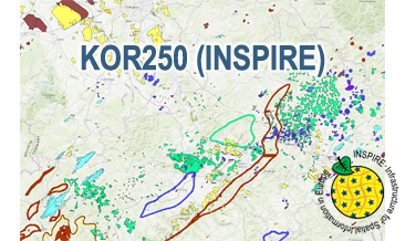
The KOR250 (INSPIRE) in the scale of 1:250,000 shows occurrences and deposits of mineral resources in Germany, which lie close to the Earth’s surface, i.e. can be mined in open-pits, quarries or near-surface mines. These mineral resources include industrial minerals, aggregates, peat, lignite, oil shales, and natural brines. The map is derived from the KOR250, the digital successor of the map series KOR200 „Map of Near-Surface Deposits of the Federal Republic of Germany 1:200,000”, which has been published since 1984. The KOR200 and KOR250 have been published by the Federal Institute for Geosciences and Natural Resources together with the State Geological Surveys of the federal states on behalf of the Federal Ministry for Economic Affairs and Energy. Primary purpose of the KOR250 is to display Germany’s potential of domestic raw materials in a comparable way. The explanations given in the printed booklets accompanying the KOR200 are not available in the digital KOR250. In the KOR250 besides the defined deposits and differently coloured areas of raw materials, "active mines" (= operations) at time of publication or "focal points of several active mines" are marked with one symbol each. These mines are not included in the KOR250 (INSPIRE) as often the headquarters of the mining company and not the mining site itself is displayed as well as in many regions the dataset is outdated. As the map sheets of the KOR200 have been generated over more than three decades the timeliness of data is extremely different. For more detail, the current large-scale raw material maps of the Federal State Geological Surveys should always be consulted. The point data displayed in KOR250 (INSPIRE) indicate very small, but worth mentioning prospects of certain raw materials. According to the Data Specification on Mineral Resources (D2.8.III.21) the content of the map is stored in two INSPIRE-compliant GML files: KOR250_EarthResource_polygon.gml comprises the mineral resources as polygons. KOR250_EarthResource_point.gml comprises the mineral resources as points. The GML files together with a Readme.txt file are provided in ZIP format (KOR250-INSPIRE.zip). The Readme.text file (German/English) contains detailed information on the GML files content. Data transformation was proceeded by using the INSPIRE Solution Pack for FME according to the INSPIRE requirements. Notes: It should be noted that according to the INSPIRE commodity code list, most magmatites and metamorphites were assigned to the two values "granite" and "basalt". From a geological point of view and with regard to its origin, this assignment is often misleading. For more information on the outcropping rock of a specific raw material occurrence, the German name from the original KOR250 was mapped to the attribute name of the class GeologicFeature. Link KOR200: https://www.bgr.bund.de/EN/Themen/Min_rohstoffe/Projekte/Rohstoffverfuegbarkeit_laufend_en/KOR_200_en.html

Aktualität des Datensatzes

Publikation 13.05.20
Letzte Änderung 17.05.24

Raumbezug

Lage der Geodaten (in WGS84)

SW Länge/Breite NO Länge/Breite
5.5°/47.25° 15.5°/55°

Koordinatensystem

Verweise und Downloads

Downloads (1)

KOR250 (INSPIRE) im Format INSPIRE-GML
[17MB]

Querverweise (2)

Geodatendienst
download
Download Service (predefined ATOM) der Bundesanstalt für Geowissenschaften und Rohstoffe (BGR) Dieser Downloaddienst stellt die von INSPIRE betroffenen und die INSPIRE-konformen Produkte der Bundesanstalt für Geowissenschaften und Rohstoffe (BGR) bereit.
Geodatendienst
WMS
INSPIRE: Map of Near-Surface Deposits of the Federal Republic of Germany 1:250,000 (KOR250) (WMS) The WMS KOR250 (INSPIRE) in the scale of 1:250,000 shows occurrences and deposits of mineral resources in Germany, which lie close to the Earth’s surface, i.e. can be mined in open-pits, quarries or near-surface mines. These mineral resources include industrial minerals, aggregates, peat, lignite, oil shales, and natural brines. The map is derived from the KOR250, the digital successor of the map series KOR200 „Map of Near-Surface Deposits of the Federal Republic of Germany 1:200,000”, which has been published since 1984. The KOR200 and KOR250 have been published by the Federal Institute for Geosciences and Natural Resources together with the State Geological Surveys of the federal states on behalf of the Federal Ministry for Economic Affairs and Energy. Primary purpose of the KOR250 is to display Germany’s potential of domestic raw materials in a comparable way. The explanations given in the printed booklets accompanying the KOR200 are not available in the digital KOR250. In the KOR250 besides the defined deposits and differently coloured areas of raw materials, "active mines" (= operations) at time of publication or "focal points of several active mines" are marked with one symbol each. These mines are not included in the KOR250 (INSPIRE) as often the headquarters of the mining company and not the mining site itself is displayed as well as in many regions the dataset is outdated. As the map sheets of the KOR200 have been generated over more than three decades the timeliness of data is extremely different. For more detail, the current large-scale raw material maps of the Federal State Geological Surveys should always be consulted. The point data displayed in KOR250 (INSPIRE) indicate very small, but worth mentioning prospects of certain raw materials. The WMS KOR250 (INSPIRE) contains the two layers MR.MineralOccurence.Commodity.Polygon (mineral resources as polygons) and MR.MineralOccurence.Commodity.Point (mineral resources as points). Via the getFeatureInfo request the user obtains additional information on the mineral resources. Notes: The colouring of the raw material occurrences in the KOR250 (INSPIRE) largely corresponds to the colouring of the original KOR250. In the INSPIRE Data Specification on Mineral Resources (D2.8.III.21) there are no portrayal rules for building raw materials and dimension stones, which constitute a large part of the raw material occurrences. It should be noted that according to the INSPIRE commodity code list, most magmatites and metamorphites were assigned to the two values "granite" and "basalt". From a geological point of view and with regard to its origin, this assignment is often misleading. For more information on the outcropping rock of a specific raw material occurrence, the German name from the original KOR250 was mapped to the attribute name of the class GeologicFeature. Link KOR200: https://www.bgr.bund.de/EN/Themen/Min_rohstoffe/Projekte/Rohstoffverfuegbarkeit_laufend_en/KOR_200_en.html
Vorschau

Nutzung

Nutzungsbedingungen

Nutzungsbestimmungen für die Bereitstellung von Geodaten des Bundes Quellenvermerk: Quelle: Bundesanstalt für Geowissenschaften und Rohstoffe (BGR)
General Terms and Conditions, s. https://www.bgr.bund.de/agb_en
Dieser Datensatz kann gemäß der "Nutzungsbestimmungen für die Bereitstellung von Geodaten des Bundes" (https://sg.geodatenzentrum.de/web_public/gdz/lizenz/geonutzv.pdf) genutzt werden.

Zugriffsbeschränkungen

Es gelten keine Zugriffsbeschränkungen

Kontakt

Ansprechpartner

Bundesanstalt für Geowissenschaften und Rohstoffe (BGR) Stilleweg 2 30655 Hannover DE

Fachinformationen

Informationen zum Datensatz

Identifikator https://registry.gdi-de.org/id/de.bund.bgr.csw/65c26532-3b26-ba11-d19e-c4b52352cedd
Digitale Repräsentation Vector
Fachliche Grundlage The KOR250 (INSPIRE) GML files are based on the spatial dataset of the Map of Near-Surface Deposits of the Federal Republic of Germany 1:250,000 (KOR250) transformed according to INSPIRE.

Zusatzinformationen

Sprache des Datensatzes Englisch

Konformität

Spezifikation der Konformität Spezifikationsdatum Grad der Konformität Geprüft mit
INSPIRE Data Specification on Mineral Resources - Technical Guidelines 10.12.13 See the referenced specification
VERORDNUNG (EG) Nr. 1089/2010 DER KOMMISSION vom 23. November 2010 zur Durchführung der Richtlinie 2007/2/EG des Europäischen Parlaments und des Rates hinsichtlich der Interoperabilität von Geodatensätzen und -diensten 08.12.10 See the referenced specification

Datenformat

Name Version Kompressionstechnik Spezifikation
INSPIRE-GML n/a

Schlagworte

INSPIRE-Themen

Mineral resources
Mineralische Bodenschätze

INSPIRE - Räumlicher Anwendungsbereich

National

ISO-Themenkategorien

geoscientificInformation

HVD-Kategorie

Erdbeobachtung und Umwelt

Suchbegriffe

Informationen zum Metadatensatz

Objekt-ID numis-metadaten-b338c66e-ad9d-434b-9212-c932020c6a44
Aktualität der Metadaten 23.04.25
Sprache Metadatensatz Englisch
XML Darstellung Metadaten als XML herunterladen
Ansprechpartner (Metadatum) geodatenmanagement@bgr.de