Geodatendienst

INSPIRE: Map of the distribution of sand and gravel in the Northern German glacial area (WMS)

Beschreibung

The WMS SuK-Nord (INSPIRE) shows the geological distribution of aggregates (sand and gravel) in Northern Germany, especially north of the southernmost maximum of the Scandinavian inland ice sheet (Saalian and Elsterian glaciation). According to the Data Specification on Mineral Resources (D2.8.III.21) and Geology (D2.8.II.4_v3.0) the map provides INSPIRE-compliant data. The WMS GK2000 Lagerstätten (INSPIRE) contains the following layers: MR.MineralOccurence.Commodity represents the distribution of sand and gravel. GE.GeomorphologicFeature shows the southernmost maximum of the Scandinavian inland ice sheet (Saalian and Elsterian glaciation).

Aktualität des Datensatzes

Publikation 19.10.23

Raumbezug

Lage der Geodaten (in WGS84)

SW Länge/Breite NO Länge/Breite
5.565°/49.25° 15.572°/55.012°

Koordinatensystem

Verweise und Downloads

Querverweise (1)

Geodatensatz
INSPIRE: Map of the distribution of sand and gravel in the Northern German glacial area The SuK-Nord (INSPIRE) shows the geological distribution of aggregates (sand and gravel) in Northern Germany, especially north of the southernmost maximum of the Scandinavian inland ice sheet (Saalian and Elsterian glaciation). According to the Data Specifications on Mineral Resources (D2.8.III.21) and Geology (D2.8.II.4_v3.0) the content of the map is stored in two INSPIRE-compliant GML files: SuK_Nord_EarthResource_polygon.gml contains the distribution of aggreagtes (sand and gravel) as polygons. SuK_Nord_GeomorphologicFeature.gml contains the southernmost maximum of the Scandinavian inland ice sheet (Saalian and Elsterian glaciation) as lines. The GML files together with a Readme.txt file are provided in ZIP format (SuK_Nord-INSPIRE.zip). The Readme.text file (German/English) contains detailed information on the GML files content. Data transformation was proceeded by using the INSPIRE Solution Pack for FME according to the INSPIRE requirements.
Vorschau

Nutzung

Nutzungsbedingungen

Nutzungsbestimmungen für die Bereitstellung von Geodaten des Bundes Quellenvermerk: Bundesanstalt für Geowissenschaften und Rohstoffe (BGR)
Dieser Datensatz kann gemäß der "Nutzungsbestimmungen für die Bereitstellung von Geodaten des Bundes" (https://sg.geodatenzentrum.de/web_public/gdz/lizenz/geonutzv.pdf) genutzt werden.

Zugriffsbeschränkungen

Es gelten keine Zugriffsbeschränkungen

Kontakt

Ansprechpartner

Bundesanstalt für Geowissenschaften und Rohstoffe (BGR) Stilleweg 2 30655 Hannover DE

DETAIL.CUSTODIAN

Bundesanstalt für Geowissenschaften und Rohstoffe (BGR)

Fachinformationen

Informationen zum Datensatz

Identifikator https://registry.gdi-de.org/id/de.bund.bgr.csw/383cf497-da29-4eda-9222-e3b1fb257947
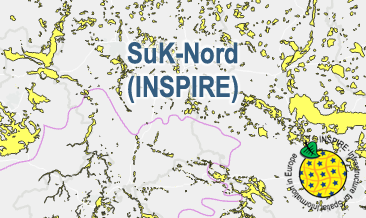
Fachliche Grundlage The WMS SuK-Nord (INSPIRE) is based on the spatial dataset of the Map of the distribution of sand and gravel in the Northern German glacial area (SuK-Nord) transformed according to INSPIRE.
Art des Dienstes view
Version OGC:WMS 1.3.0

Operation

Name der Operation Beschreibung der Operation Aufruf der Operation
GetCapabilities https://services.bgr.de/wms/inspire_mr/suk_nord/?
GetMap https://services.bgr.de/wms/inspire_mr/suk_nord/?

GetCapabilities Dokument

Zusatzinformationen

Konformität

Spezifikation der Konformität Spezifikationsdatum Grad der Konformität Geprüft mit
Technical Guidance for the implementation of INSPIRE View Services 04.04.13
VERORDNUNG (EG) Nr. 976/2009 DER KOMMISSION vom 19. Oktober 2009 zur Durchführung der Richtlinie 2007/2/EG des Europäischen Parlaments und des Rates hinsichtlich der Netzdienste 20.10.09

Datenformat

Name Version Kompressionstechnik Spezifikation
WMS OGC:WMS 1.3.0

Schlagworte

INSPIRE-Themen

Geologie
Geology
Mineral resources
Mineralische Bodenschätze

INSPIRE - Räumlicher Anwendungsbereich

Regional

Suchbegriffe

Norddeutschland
Northern Germany
gravel
infoMapAccessService
inspireidentifiziert
occurrence
opendata
sand

Informationen zum Metadatensatz

Objekt-ID numis-metadaten-7f44d8c7-581d-4cd2-983f-fb112a1fc12a
Aktualität der Metadaten 23.04.25
Sprache Metadatensatz Englisch
XML Darstellung Metadaten als XML herunterladen
Ansprechpartner (Metadatum) geodatenmanagement@bgr.de