| Publikation | 01.04.15 |
|---|
| SW Länge/Breite | NO Länge/Breite | |
|---|---|---|
| -180°/-90° | 180°/90° |
| Identifikator | 3a16e5a7-c473-442b-88b4-6ee1ff20b98b |
|---|---|
| Digitale Repräsentation | Vector |
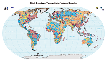
| Fachliche Grundlage | World-wide Hydrogeological Mapping and Assessment Programme (WHYMAP) |
| Sprache des Datensatzes | Englisch |
|---|
| Name | Version | Kompressionstechnik | Spezifikation |
|---|---|---|---|
| Shapefile | n/a |
| Objekt-ID | numis-metadaten-0cf5c86b-ac00-4c3d-845b-792f8bdce023 |
|---|---|
| Aktualität der Metadaten | 12.03.25 |
| Sprache Metadatensatz | Englisch |
| XML Darstellung | Metadaten als XML herunterladen |
| Ansprechpartner (Metadatum) | geodatenmanagement@bgr.de |
