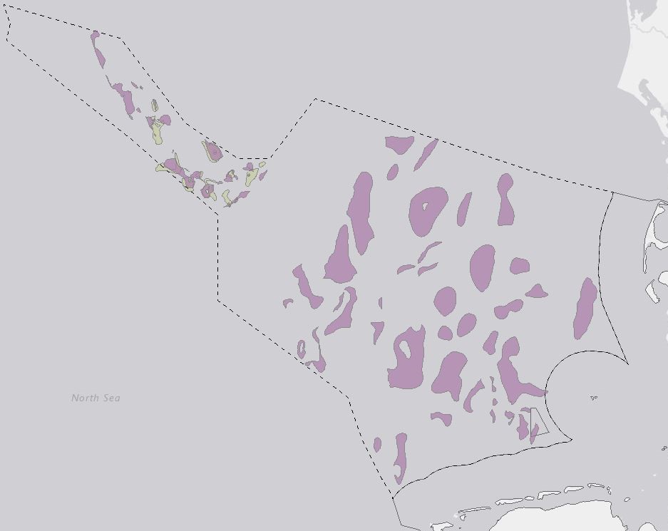
Within the framework of the GEOSTOR Project, the CO2 storage potential of the Jurassic succession in the German Central Graben was analysed. Twelve potential trap structures were initially mapped along the base of the Kimmeridge Clay Formation, which serves as the primary seal for potential reservoir sandstones within the Central Graben Subgroup. The Kimmeridge Clay Formation is generally continuously distributed across the German Central Graben, with only localized penetrations by rising salt diapirs. In contrast, the Central Graben Subgroup, serving as a potential reservoir unit, exhibits an uneven distribution across the area, limiting the presence and continuity of reservoir rocks within each trap structure. To further delineate the spatial extent of the mapped reservoir structures, the base of the Central Graben Subgroup was used as an additional reference layer. Due to the intermittent nature of Jurassic sandstones within the Central Graben Subgroup, a subsequent analysis classified each structure based on borehole data to confirm the presence of reservoir sands. Structures were categorized as ‘proven,’ ‘not present,’ or ‘uncertain’ depending on sandstone availability and continuity within the trap. All mapped reservoir structures are buried at depths ranging from 2225 to 3043 meters (apex depth) and are considered closed systems, situated within a complex structural network of salt diapirs, faults, and pinch-outs. Capacity calculations were conducted following the method outlined by Fuhrmann et al. (2024), and the horizons used for mapping are based on the work of Müller et al. (2023) and Thöle et al. (2021). Fuhrmann, A., Knopf, S., Thöle, H., Kästner, F., Ahlrichs, N., Stück, H.L., Schlieder-Kowitz, A., Kuhlmann, G., (2024). CO2 storage potential of the Middle Buntsandstein Subgroup-German sector of the North Sea. International Journal of Greenhouse Gas Control 136. Müller, S.M., Jähne-Klingberg, F., Thöle, H., Jakobsen, F.C., Bense, F., Winsemann, J. & Gaedicke, C. (2023). Jurassic to Lower Cretaceous tectonostratigraphy of the German Central Graben, southern North Sea. – Netherlands Journal of Geosciences, 102: e4. DOI:10.1017/njg.2023.4 Thöle, H., Jähne-Klingberg, F., Doornenbal, H., den Dulk, M., Britze, P. & Jakobsen F. (2021). Deliverable 3.8 – Harmonized depth models and structural framework of the NL-GER-DK North Sea. GEOERA 3DGEO-EU; 3D Geomodeling for Europe; project number GeoE.171.005. Report.
CO2 storage potentials in the Exclusive Economic Zone (EEZ) of the German North Sea - Results of the GEOSTOR-Project (WMS) (WMS)
Storage of CO2 in deep geological formations is one possibility of reducing CO2 emissions from industry that are difficult to avoid. High-quality geological models and capacity estimates are crucial for the successful planning and implementation of safe storage projects. This study analyses the storage potential of the Middle Buntssandstein (Lower Triassic) and Lower to Middle Jurassic within the Exclusive Economic Zone (EEZ) of the German North Sea. Link https://geostor.cdrmare.de/
Dieser Datensatz kann gemäß der "Datenlizenz Deutschland Namensnennung 2.0" (https://www.govdata.de/dl-de/by-2-0) unter Angabe des Quellenvermerks "GEOSTOR-SpPotJura, BGR, 2024" genutzt werden.
Zugriffsbeschränkungen
Es gelten keine Zugriffsbeschränkungen
Kontakt
Ansprechpartner
Bundesanstalt für Geowissenschaften und Rohstoffe (BGR)
Stilleweg 2
30655 Hannover
Deutschland