public
Geodatensatz
Open Data
CO2 storage potential of the Middle Buntsandstein Subgroup - EEZ of the German North Sea
Beschreibung
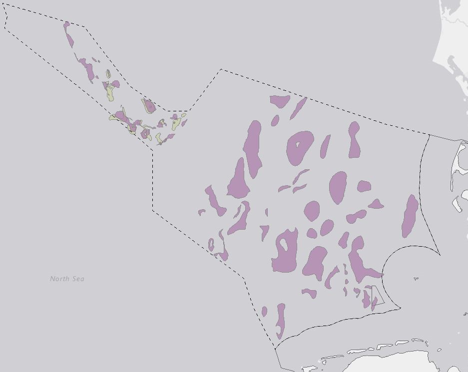
The CO2 storage potential of the Middle Buntsandstein Subgroup within the Exclusive Economic Zone (EEZ) of the German North Sea was analysed within the framework of the GEOSTOR-Project. A total of 71 potential storage sites were mapped based on existing 3D models, seismic and well data. Static CO2 capacities were calculated for each structure using Monte Carlo simulations with 10,000 iterations to account for uncertainties. All potential reservoirs were evaluated based on their static capacity, burial depth, top seal integrity and trap type. Analysis identified 38 potential storage sites with burial depths between 800 m and 4500 m, reservoir capacities (P50) above 5 Mt CO2 and suitable sealing units. The best storage conditions are expected on the West Schleswig Block where salt-controlled anticlines with moderate burial depths, large reservoir capacities and limited lateral flow barriers are the dominant trap types. Relatively poor storage conditions can be anticipated for small (P50 <5 Mt CO2), deeply buried (> 4500 m) and structurally complex potential storage sites in the Horn and Central Graben. For more detailed information on the methodology and findings, please refer to the full publication: Fuhrmann, A., Knopf, S., Thöle, H., Kästner, F., Ahlrichs, N., Stück, H. L., Schlieder-Kowitz, A. und Kuhlmann, G. (2024) CO2 storage potential of the Middle Buntsandstein Subgroup - German sector of the North Sea. Open Access International Journal of Greenhouse Gas Control, 136 . Art.Nr. 104175. DOI 10.1016/j.ijggc.2024.104175
Aktualität des Datensatzes
Raumbezug
Lage der Geodaten (in WGS84)
|
SW Länge/Breite |
NO Länge/Breite |
|
3.349°/53.244° |
9.827°/55.919° |
Verweise und Downloads
Querverweise (1)
settings
Geodatendienst
WMS
CO2 storage potentials in the Exclusive Economic Zone (EEZ) of the German North Sea - Results of the GEOSTOR-Project (WMS) (WMS)
Storage of CO2 in deep geological formations is one possibility of reducing CO2 emissions from industry that are difficult to avoid. High-quality geological models and capacity estimates are crucial for the successful planning and implementation of safe storage projects. This study analyses the storage potential of the Middle Buntssandstein (Lower Triassic) and Lower to Middle Jurassic within the Exclusive Economic Zone (EEZ) of the German North Sea. Link https://geostor.cdrmare.de/
Weitere Verweise (5)
information
International Journal of Greenhouse Gas Control, No. 136
information
Karte im BGR-Geoviewer
information
Geostor-Webseite
information
Geostor-Datenkatalog
information
BGR-Projektseite
Identifikator des übergeordneten Metadatensatzes
ec1975a4-e9ac-44be-b19f-f6e01ef5177f
Nutzung
Nutzungsbedingungen
Dieser Datensatz kann gemäß der "Datenlizenz Deutschland Namensnennung 2.0" (
https://www.govdata.de/dl-de/by-2-0) unter Angabe des Quellenvermerks "GEOSTOR-SpPotMBst, BGR, 2024" genutzt werden.
Zugriffsbeschränkungen
Es gelten keine Zugriffsbeschränkungen
