| Publikation | 22.02.23 |
|---|
| SW Länge/Breite | NO Länge/Breite | |
|---|---|---|
| -69.01°/80.42° | -59.9°/82.21° |
| Identifikator | d9eb00fe-93f2-ee92-1102-eb9081d484c4 |
|---|---|
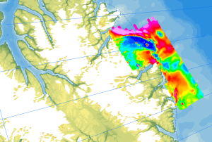
| Fachliche Grundlage | The aeromagnetic data were collected by GSC Canada and BGR as part of the NARES I expeditions between Ellesmere Island and NW Greenland. |
| Sprache des Datensatzes | Englisch |
|---|
| Name | Version | Kompressionstechnik | Spezifikation |
|---|---|---|---|
| GeoTIFF | n/a | ||
| shp | n/a | ||
| WMS | OGC:WMS1.3.0 |
| Objekt-ID | numis-metadaten-6a024df8-519d-48c6-baf3-1fb71b071b85 |
|---|---|
| Aktualität der Metadaten | 13.01.26 |
| Sprache Metadatensatz | Englisch |
| XML Darstellung | Metadaten als XML herunterladen |
| Ansprechpartner (Metadatum) | geodatenmanagement@bgr.de |
