| Publikation | 25.09.17 |
|---|
| SW Länge/Breite | NO Länge/Breite | |
|---|---|---|
| -180°/-90° | 180°/90° |
| Identifikator | 6e557f76-ac0a-404b-bad1-045b291d88cd |
|---|---|
| Digitale Repräsentation | Vector |
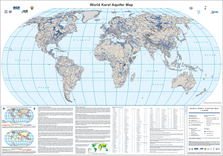
| Fachliche Grundlage | World-wide Hydrogeological Mapping and Assessment Programme (WHYMAP) |
| Sprache des Datensatzes | Englisch |
|---|
| Spezifikation der Konformität | Spezifikationsdatum | Grad der Konformität | Geprüft mit |
|---|---|---|---|
| VERORDNUNG (EG) Nr. 1089/2010 DER KOMMISSION vom 23. November 2010 zur Durchführung der Richtlinie 2007/2/EG des Europäischen Parlaments und des Rates hinsichtlich der Interoperabilität von Geodatensätzen und -diensten | 08.12.10 | siehe dazu die angegebene Durchführungsbestimmung |
| Name | Version | Kompressionstechnik | Spezifikation |
|---|---|---|---|
| Shapefile | n/a |
| Objekt-ID | numis-metadaten-473d851c-4694-4050-a37f-ee421170eca8 |
|---|---|
| Aktualität der Metadaten | 07.03.25 |
| Sprache Metadatensatz | Englisch |
| XML Darstellung | Metadaten als XML herunterladen |
| Ansprechpartner (Metadatum) | geodatenmanagement@bgr.de |
