| Publikation | 25.05.22 |
|---|
| SW Länge/Breite | NO Länge/Breite | |
|---|---|---|
| -180°/-90° | 180°/90° |
| Identifikator | 4258baf3-0a4f-ee35-f820-a1d13c68ac7e |
|---|---|
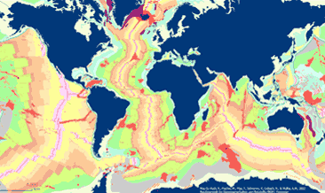
| Fachliche Grundlage | Map based on extracts from Bouysse et al. (2010) © CGMW, and Bryan & Ernst (2008), using the Esri Basemap, HERE, Garmin, FAO, NOAA, USGS, © OpenStreetMap contributors and the GIS User Community Bouysse, P. et al (2010): Geological Map of the World. Commission of the Bryan, S. E. and Ernst R. E., 2008. Revised definition of Large Igneous Provinces (LIPs), Elsevier, Earth Science Review 86 |
| Art des Dienstes | view |
|---|---|
| Version | OGC:WMS 1.3.0 |
| Name der Operation | Beschreibung der Operation | Aufruf der Operation |
|---|---|---|
| GetCapabilities | https://services.bgr.de/wms/geologie/seafloorgeol/? | |
| GetMap | https://services.bgr.de/wms/geologie/seafloorgeol/? |
| Spezifikation der Konformität | Spezifikationsdatum | Grad der Konformität | Geprüft mit |
|---|---|---|---|
| VERORDNUNG (EG) Nr. 976/2009 DER KOMMISSION vom 19. Oktober 2009 zur Durchführung der Richtlinie 2007/2/EG des Europäischen Parlaments und des Rates hinsichtlich der Netzdienste | 20.10.09 | siehe dazu die angegebene Durchführungsbestimmung |
| Name | Version | Kompressionstechnik | Spezifikation |
|---|---|---|---|
| png | n/a | ||
| jpeg | n/a | ||
| gif | n/a |
| Objekt-ID | numis-metadaten-3dcc072e-2e76-4e62-bb35-e80be0523753 |
|---|---|
| Aktualität der Metadaten | 04.03.24 |
| Sprache Metadatensatz | Englisch |
| XML Darstellung | Metadaten als XML herunterladen |
| Ansprechpartner (Metadatum) | geodatenmanagement@bgr.de |
