| Publikation | 02.07.20 |
|---|
| SW Länge/Breite | NO Länge/Breite | |
|---|---|---|
| 5.56°/47.14° | 15.58°/55.09° |
| Identifikator | https://registry.gdi-de.org/id/de.bund.bgr.csw/66d89ccf-ce46-9c84-a0b6-bcb3a74d70fb |
|---|---|
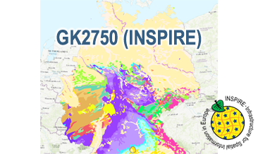
| Fachliche Grundlage | The WMS GK2750 Geology (INSPIRE) based on the spatial dataset of the Geological Map of Germany 1:2,750,000 - Geology (GK2750 Geology) transformed according to INSPIRE. |
| Art des Dienstes | view |
|---|---|
| Version | OGC:WMS 1.3.0 |
| Name der Operation | Beschreibung der Operation | Aufruf der Operation |
|---|---|---|
| GetCapabilities | https://services.bgr.de/wms/inspire_ge/gk2750/? | |
| GetMap | https://services.bgr.de/wms/inspire_ge/gk2750/? |
| Spezifikation der Konformität | Spezifikationsdatum | Grad der Konformität | Geprüft mit |
|---|---|---|---|
| Technical Guidance for the implementation of INSPIRE View Services | 04.04.13 | See the referenced specification | |
| VERORDNUNG (EG) Nr. 976/2009 DER KOMMISSION vom 19. Oktober 2009 zur Durchführung der Richtlinie 2007/2/EG des Europäischen Parlaments und des Rates hinsichtlich der Netzdienste | 20.10.09 | See the referenced specification |
| Name | Version | Kompressionstechnik | Spezifikation |
|---|---|---|---|
| png | n/a | ||
| jpeg | n/a | ||
| gif | n/a |
| Objekt-ID | numis-metadaten-1a509ef3-55e5-426f-8f58-d8f3d2690bc1 |
|---|---|
| Aktualität der Metadaten | 23.01.24 |
| Sprache Metadatensatz | Englisch |
| XML Darstellung | Metadaten als XML herunterladen |
| Ansprechpartner (Metadatum) | geodatenmanagement@bgr.de |
