| Publikation | 12.12.13 |
|---|
| SW Länge/Breite | NO Länge/Breite | |
|---|---|---|
| 5.482°/47.175° | 15.483°/55.061° |
| Identifikator | 9d107171-5a20-42dd-84e2-ec5b30975e3a |
|---|---|
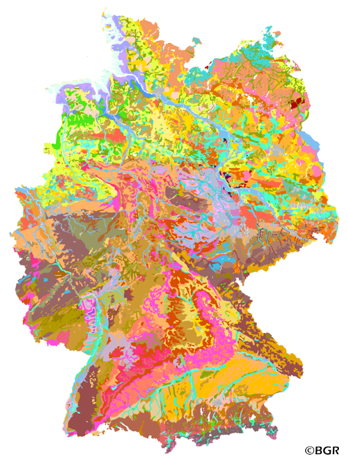
| Fachliche Grundlage | BGR (BÜK1000, 0.1), Forstplanungsämter und Staatliche Geologische Dienste der Länder 1994. |
| Art des Dienstes | view |
|---|---|
| Version | OGC:WMS 1.3.0 |
| Name der Operation | Beschreibung der Operation | Aufruf der Operation |
|---|---|---|
| GetCapabilities | https://services.bgr.de/wms/boden/buek1000en/? | |
| GetMap | https://services.bgr.de/wms/boden/buek1000en/? |
| Spezifikation der Konformität | Spezifikationsdatum | Grad der Konformität | Geprüft mit |
|---|---|---|---|
| VERORDNUNG (EG) Nr. 976/2009 DER KOMMISSION vom 19. Oktober 2009 zur Durchführung der Richtlinie 2007/2/EG des Europäischen Parlaments und des Rates hinsichtlich der Netzdienste | 20.10.09 | siehe dazu die angegebene Durchführungsbestimmung |
| Name | Version | Kompressionstechnik | Spezifikation |
|---|---|---|---|
| png | n/a | ||
| jpeg | n/a | ||
| gif | n/a |
| Objekt-ID | numis-metadaten-0a69e00d-4a6c-467e-90b3-9d76a538ef18 |
|---|---|
| Aktualität der Metadaten | 23.01.24 |
| Sprache Metadatensatz | Englisch |
| XML Darstellung | Metadaten als XML herunterladen |
| Ansprechpartner (Metadatum) | geodatenmanagement@bgr.de |
